The Woronora River is situated in the southern suburbs of Sydney on Dharawal country, flowing through the Woronora Plateau to the Georges River in the Sutherland Shire. Woronora is an Indigenous word meaning ‘black rock’.
The Woronora River catchment area (the area where water is collected from, that feeds into the river), covers a much larger footprint, including areas covered by Campbelltown, Liverpool and Wollongong City Councils. It is an extensive river system on its own. The largest tributary of the Georges River, its upper reaches are relatively undeveloped and managed by the Sydney Catchment Authority.
The Woronora River rises on the north-western slopes of the Illawarra mountain range and has its origin from Waratah Rivulet, near Darkes Forest. The river flows generally north for approximately 36 kilometres, joined by three main tributaries, before reaching the Georges River, between Como and Illawong. The total catchment area of the river is approximately 174 square kilometres.
The Woronora Dam is a major feature of the catchment area. The Dam provides drinking water for the Sutherland Shire and some surrounding suburbs. Downstream of the dam the river passes through sandstone gorge terrain with the majority of the 95 square kilometres covered in eucalypt forest. There is increasing urban development along the catchment ridgelines. There is residential development along the banks and floodplain of the final 11 kilometres of the Woronora River before it joins the Georges River near Como Bridge.
The Woronora River is a perennial river, meaning it has a continuous flow of surface water throughout the year during seasons of normal rainfall. It is also a tidal river, meaning that ocean tides can also affect the flow and height of river levels.
Suburbs and locations along the Woronora River include:
The Woronora River is a pristine waterway traversing through deep valleys and peaceful surroundings. It is a place of great beauty offering boating, canoeing, kayaking, swimming and fishing, with plenty of opportunity to stop off for a picnic and bushwalking.
The Woronora Valley is an area of great natural beauty and regional significance. The valley is home to several endangered ecological communities, threatened species and a diverse range of vegetation types including wetlands, saltmarsh, woodlands, forests, and heath.
The information contained on this website is based on knowledge and understanding at the time of compilation (2023). However, because of advances in knowledge, users are reminded of the need to ensure that information upon which they rely is up to date. NSW State Emergency Service (NSW SES) takes no responsibility for the accuracy, currency, reliability, and correctness of any information on the site (including, without limitation, any of the information provided by third parties) nor for the accuracy, currency, reliability and correctness of links or references to information sources with regard to the site. While all reasonable care has been taken in the compilation, to the extent permitted by law, NSW State Emergency Service and the State of New South Wales and its employees and agents exclude all liability for the accuracy or completeness of the information, or for any injury, loss, or damage whatsoever (including without limitation liability for negligence and consequential losses) suffered by any person acting or purporting to act in reliance upon anything contained herein.
Every flood is different, and floods can change quickly.
Floods are a natural occurrence in the Australian landscape. They are necessary for the health of our river ecosystems. Many of our farmlands have rich and fertile soil because of the flooding that happens in Australia.
It is when the environments we build intersect with this natural occurrence, that we find disasters which impact on our lives and livelihoods.
Knowing the flood potential of where you live, work and visit in Australia is important to keep yourself, your family and others safe during floods.
Visit the NSW SES flood information pages for more information on floods and to find out what you can do before, during and after floods, including:
You may not always receive an official warning before floods begin to impact you, therefore it is important to be aware of the flood situation in your local area.
Monitor the local situation. Know the height and rate at which floodwater is rising. Maintain contact with other people in your local community and listen to your local radio stations to receive and share information, updates and advice on the flood situation.
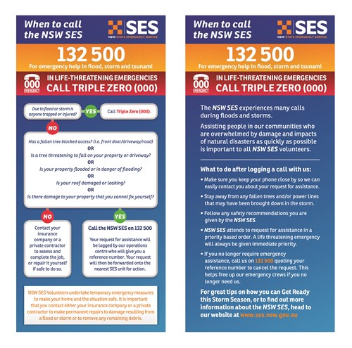
Severe Weather Warnings and Severe Thunderstorm Warnings issued by the Bureau of Meteorology warn of the possibility of flash flooding.
When flash flooding is likely, it is best to evacuate low-lying homes and businesses well before flash flooding begins, but only if it is safe to do so. If you are trapped by rising floodwater, seek refuge in the highest part of a sturdy building or on high land. Stay there and call '000' (triple zero) if you need rescue.
The Bureau of Meteorology issue Flood Watches and Flood Warnings that are linked to gauges along rivers in NSW. The Woronora River gauge is located at the Woronora Bridge.
A Flood Warning is issued by the Bureau of Meteorology when flooding is expected to occur or is happening.
Flood Warnings provide a predicted flood level and time at which a river will reach that level.
Flood Warnings are issued in relation to flood gauges which are situated at a certain point on a river. They may contain observed, peak or predicted river heights.
Flood Warnings will be issued as:
Flooding which causes inconvenience such as closing of minor roads and the submergence of low-level bridges. The lower limit of this class of flooding is the initial flood level at which landholders and/or townspeople begin to be affected in a significant manner that requires the issuing of a public flood warning by the Australian Government Bureau of Meteorology.
Flooding which inundates low-lying areas, requiring removal of stock and/or evacuation of some houses. Main traffic routes may be flooded.
Flooding which causes inundation of extensive rural areas, with properties, villages and towns isolated and/or appreciable urban areas flooded.
Observed River Height
Depth of water (in metres) at a river height measuring gauge located along the river. In most cases, a zero reading is the lowest water level that is reached during dry conditions. In many tidal areas, as well as a few inland areas, river levels are expressed in metres above mean sea level or Australian Height Datum (AHD).
Peak River Height
Highest river height (in metres) observed during a flood event at the specified site on the river.
Predicted River Height
The height (in metres) to which the river is predicted to rise at the river gauge referred to in the warning.
The actual depth of flood water will vary across the floodplain. Knowledge of past flood events, as well as estimates of flood levels from flood studies, are used by local Councils, emergency services and landowners to determine which areas are likely to be flooded from the predicted river height.
The accuracy of this prediction depends on a number of factors. Predicted river heights are subject to forecasting error and are regularly updated as more information becomes available.
For detailed information on the NSW SES Flood Warning Products, visit the NSW SES Our Warnings webpage or the Australian Warning System tile on these pages.
Flood
Flash Flood
Overland Flow
The NSW Flood Data Access Program is a joint partnership between the NSW State Emergency Service and the NSW Office of Environment and Heritage.
The program aims to improve the sharing of key flood data within government and to other stakeholders, so that this information is more broadly available to be considered in decision making.
The NSW Flood Data Access Program has two main initiatives:
The development of the NSW Flood Database and NSW Flood Data Portal has been supported with funding provided through the Natural Disaster Resilience Program. The NSW Government invested in the ongoing management of statewide flood information, through ongoing funding of this program.
NSW Flood Data Portal
The NSW Flood Data Portal aims to improve the sharing of key flood data within government and to other stakeholders so that this information is more broadly available to be considered in decision making.
Data contained in the NSW Flood Data Portal is entered by each Local Council at the completion of floodplain risk management studies undertaken in their area. This data is then made available to government and other stakeholders via the portal.
Note: Responsibility for providing flood information to the public remains with Local Council. Therefore, queries in relation to flooding should be directed to the relevant local council (https://www.olg.nsw.gov.au/public/local-government-directory/)
NSW Flood Database
The NSW Flood Database aims to aggregate information on flood risk at both local and state government levels. It provides a strategic understanding of flood risk, enabling for more informed and effective flood risk and emergency response management at local, regional and state government scales.
This project is identified as a priority action in the NSW Government 2021 Plan.
The Woronora River has a long history of flooding. Significant floods have occurred on the Woronora River since the 1930's, with flood events in recent decades being in 2000, 2012, 2013, 2016, 2020 and the highest being in July 2022. Significant floods will happen along the Woronora River again and may even be greater than those experienced or behave differently than those in the past.
Data from flood studies have been used to create flood intelligence for the Woronora River. This includes modelled flood possibilities and data from historical floods. The collection of flood data and intelligence is a continual process through community feedback, flood modelling and assessing actual floods.
It is important to understand the local risks, consequences and timings to act on Warnings issued by the NSW SES to ensure your safety and the safety of your family, households, friends, neighbours, pets, and businesses.
Visit the Sutherland Shire Council Website for local information on flooding along the Woronora River.

The collection of flood data and intelligence for Woronora River is an ongoing process through community feedback, flood modelling and damage assessment after actual flood events. Flood studies that model flood behaviour in simulated weather scenarios and recorded observations of historical floods are used to develop and refine local flood intelligence to consider possible impacts of flooding on communities along the river.
It is important to understand the local risks, consequences, and timings to act on Warnings issued by the NSW SES to ensure your safety and the safety of your family, households, friends, neighbours, pets, and businesses.
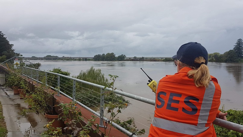
Rapid and dangerous river rises can happen on the Woronora River with some areas being susceptible to inundation and requiring evacuation for the safety of the local community. As isolation is also possible when significant roads are cut by floodwaters or if major utilities are impacted, earlier evacuation may be required. It is better to move people safely and avoid being cut off without power, water, sewerage, and other essentials. Travelling on a flooded river is dangerous and rescue may not be an option as it may be unsafe for NSW SES volunteers to launch flood boats.
It is important to monitor all warnings issued by the Bureau of Meteorology and the NSW SES for the Woronora River and follow the advice in these warnings. Decisions to release warnings are based on the protection of life.
Monitor Woronora river heights at the Woronora River Gauge (Woronora Bridge)
Monitor Woronora river heights at the Woronora River at the Needles
Monitor Woronora river heights the Woronora River Woronora Dam


Radio stations that may broadcast local warnings:
Sutherland Shire Council provides local information on flood prone land along the Woronora River in the planning/zoning layer of their Shire Maps Sutherland Shire Council.
Though most areas are subject to some flash flooding in heavy rains and tidal impacts are common along the foreshore, riverine flooding that could cause extended inundation or isolation is predominantly around low-lying areas of the river in Woronora and Bonnet Bay.
As flood intelligence is updated and made publicly available, the NSW SES will identify the specific communities at risk in the area.
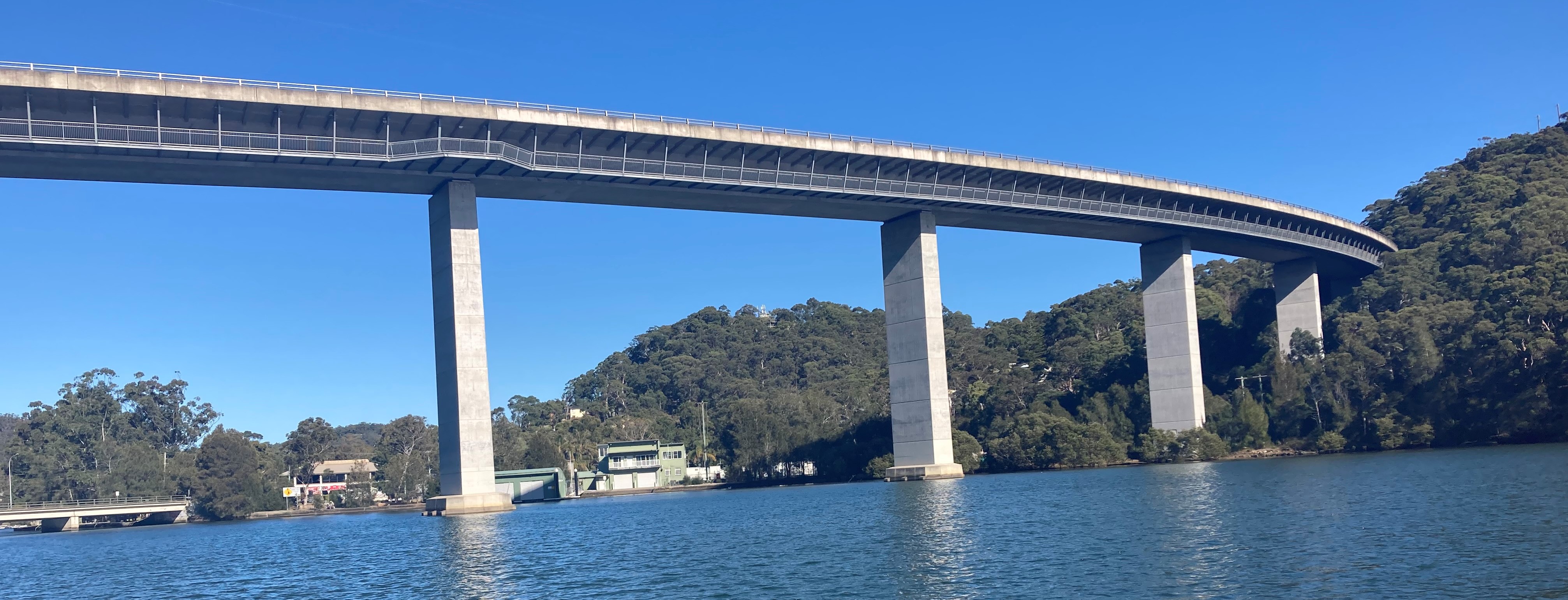
The Woronora Dam, constructed between 1927 and 1941, is positioned around 50 kilometres south of Sydney. The main purpose is to provide water to communities south of the Georges River and was the fifth and final pre-World War II dam that ensured a stable water source for Sydney, with a capacity of 71,790 ML and a surface area of 380 hectares.
The need for the dam became evident in 1911 when initial water supply efforts were established for the Sutherland Shire and as a solution, a 15-centimetre pipeline was laid from Penshurst Reservoir across the Georges River at Tom Uglys Point to Miranda. As residential, industrial, and commercial demands grew south of the Georges River, a larger water supply was essential and led to the creation of the Woronora Dam, strategically positioned about 24 kilometres upstream from the confluence of the Woronora River and the Georges River. The site features a narrow gorge with steep Hawkesbury sandstone sides, descending over 100 metres.
The Woronora Dam supplies water to nearby communities such as Helensburgh and Engadine and parts of the Sutherland Shire through the nearby Woronora water filtration facility, which is one of Sydney's nine water treatment facilities, operated either by Sydney Water or in collaboration with private companies.
In essence, the Woronora Dam is a vital infrastructure, effectively addressing the region's evolving water requirements and serving present and future demands. For further information, with links to real time data on Sydney Dam water levels and outflows refer to WaterNSW website.
WaterNSW are responsible for flood operations at Woronora Dam and provide real-time advice for the public to opt-in to through their Early Warning Network.
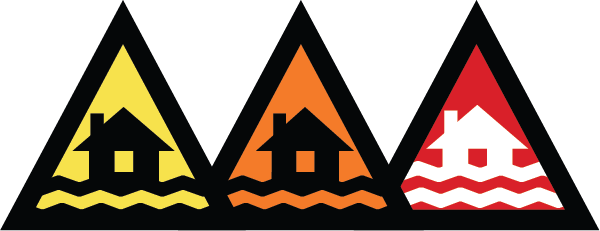
The NSW SES moved to the Australian Warning System (AWS) for flood and tsunami warnings on 30 September 2022.
The AWS is a nationally consistent, three-tiered approach designed to make warnings clearer and lead people to take action ahead of severe weather events.
The warning system comprises warning levels, action statements, hazard icons, colours and shapes.
There are three levels within the AWS - Advice (yellow), Watch & Act (orange) and Emergency Warning (red).

Notifications issued under the AWS will differ in Location and Hazard, Action Statements (relevant to the hazard and timestamp of the hazard) and Severity Warning Level (Severity).

Advice, Watch and Act and Emergency Warnings will be issued through the NSW SES website homepage and HazardWatch
Notifications may also be broadcast through media outlets and social media platforms. Share these warnings with family, friends and neighbours.
Conditions can change quickly. Continually check for updated notifications.
Providing communities with timely flood information, actions and advice, reduces the impact of floods on lives, businesses and properties.
For more information on AWS warnings and action you need to take, go to Australian Warning System - Our warnings
The move to the AWS is exciting as it significantly improves the way NSW SES warn communities along the Woronora River during floods.
This is especially important for communities along the Woronora River as some community members follow an old color-coding system adopted in 1998 (from the Woronora Floodplain Management Study or Flood Education Strategy), to interpret and understand flood risk. The new warning system, along with NSW SES Planning processes, supersedes this old system.
The improved way of having consistent warnings directly links to triggers that have been refined and updated to include intelligence and feedback. This is important as it has been applied to local emergency management sectors to create the adequate sequence of warnings for communities. This accounts for those changes seen since the previous study.
It is important for communities to understand how to use these tools and warnings to support making informed decisions when it floods.
Locations along the Woronora River will receive a sequence of targeted Warnings specific to the local impacts of flooding.
For example:


The Warnings will escalate and de-escalate as flood risk increases and decreases. The warnings will contain further information on flood consequences, river heights and actions you can do to keep safe.
There may even be Warnings issued for the impact of tides on river levels (even when the Woronora River is not flooding).
There is also the Hazards Near Me App that assists community know what to do in response to warnings in their area and this has been tailored specific to communities across NSW, including Woronora. Communities can set their Watch Zones to receive future local warnings through the App.
Every flood is different, and the NSW SES can never give you certainty in relation to a flood due to high variance and differing influences that come into play. It is important that communities of NSW understand this.
The NSW SES are working closing with Sutherland Shire Council to support engaging communities about the changes, the new AWS and using every opportunity to listen to and adopt new local flood information and feedback from an Emergency Management perspective, into the new warnings system.


The Hazards Near Me App is an interactive platform that displays NSW SES Flood Warnings (Advice, Watch and Act and Emergency Warnings).
Set your WATCH ZONE to ensure you receive warnings directly, about events near you or in areas you are travelling to or have family or friends.
Information can be displayed in a map or list view. It includes clear steps about how to stay safe in flood events.
You can find current information about local emergencies on Hazards Near Me. The app shows information provided from emergency services on:
bush fires
floods
tsunamis
advice on what to do to stay safe
The app also provides other warnings and activities in your area:
fire danger ratings
total fire bans
hazard reduction activities
The app can send you push notifications when there are new incidents or when information changes.
![]() Check out and then download to your phone, the Hazards Near Me app here:
Check out and then download to your phone, the Hazards Near Me app here:
Images were either provided to the NSW SES or are publicly available.
If you have any flood images of the Woronora River, the NSW SES would like to share these on this page.
Please Contact Us.
If you have any feedback on locations and years for the below images, please send this through the Contact Us page as well.
Remembering floods can be traumatic for some people. The NSW SES share these images to remind communities that flooding has happened and will happen again.
If these images cause distress in any way, the NSW SES can remove them.


The NSW SES Disaster Awareness Survey is a generic survey used in many locations across NSW. The survey measures impact of a campaign and/or engagement delivery in an area that focusses on raising community levels of awareness, knowledge and actions about flood, over time. Community responses to the surveys will help measure how effective the campaign has been.
The Woronora River Disaster Awareness Survey targets people who live and work in local areas along the Woronora River, particularly:
and waterfront areas of:
There are three surveys that aim to measure an initial level of awareness, knowledge and, actions and then compare these to later results from the following two surveys, one just after the engagement activities and the last one six months later to test for maintenance of levels.
NSW SES respects the privacy of people (Privacy Statement) and there are some answers to Frequently Asked Questions (FAQs) about the surveys once you begin the survey online.
NSW SES values the opinions of children and young people. For this reason, we require children and young people under the age of 18 to get the consent of a parent or guardian before they participate in a survey.
Responses will help measure the success of the campaigns, but they will also provide information on how the NSW SES can best direct preparedness community engagement work in these areas in the future, to build and support local resilience.
The initial survey will be promoted locally. Respondents who give their email details, will receive the follow-up surveys.
Overall results will be published on social media once the third survey has closed.

NSW SES have completed survey 1 in the Woronora River Flood Awareness Project.
The survey looked at local awareness and knowledge ratings and actions needed to be done and actions done to prepare for floods.
Subsequent surveys will be used to measure against these results to determine shifts in awareness, knowledge and actions for communities along the Woronora River.
60 surveys were completed, with 57 being from the targeted areas.
The overall average across flood awareness and knowledge was a rating of 3.64 out of 5
Levels of awareness had an average of 3.54
Levels of knowledge has an average of 3.78
These overall ratings show that flood awareness and knowledge are high in areas along the Woronora River.
Increasing the knowledge of local flood impacts and consequences will be important to grow this average
Engagement activities will focus on awareness and local flood knowledge as well as the Australian Warning System and how this relates to local flood consequences

Local flood information is important to include in engagement activities to increase local flood risk awareness, including:
Almost 50% of respondents will wait for a warning and then follow advice.
Knowing the Australian Warning System and creating a Watch Zone are key messages to engage with communities along the Woronora River.
Just over 20% indicate that they would stay in place regardless.
Larger floods are possible. Staying is risking lives.
61% will act on warnings or act early.
37% would stay or rely on being told or others moving, before moving.
1/3 of people in the target locations need messages about acting early.

Comparison of Actions Needed and Actions Done
|
ACTIONS NEEDED |
# |
# |
ACTIONS DONE |
|
Know the safest place to go |
49 |
33 |
Identified the safest place to go |
|
Know where to find official warnings |
46 |
41 |
I know where to find official warnings |
|
Make an emergency plan |
45 |
26 |
Plan in place for disasters |
|
Insure my home and contents |
45 |
44 |
Insured my home and contents |
|
Move items to higher ground |
45 |
21 |
Moved items to higher ground |
|
List key contacts |
36 |
20 |
List key contacts |
|
Make arrangements for pets |
36 |
21 |
Arrangements for pets |
|
Stock water and essential supplies |
35 |
18 |
Stocked water and essential supplies |
|
Secure loose items around home |
32 |
21 |
Secured loose items around home |
|
Swap numbers with neighbours |
29 |
36 |
Swapped numbers with my neighbours |
Areas of focus for further engagement are making an emergency plan for floods based on local flood information including:
Linking local flood plans NSW SES warnings (create a Watch Zone), identify triggers for action, including:
The Woronora River flows through the following Local Government Areas
Local Councils conduct Flood Studies on the impacts of floodwater and may have specific height data for residents and businesses.
Here you can find links to a range of other resources and information from the NSW SES.
Flood safety and awareness
Schools resources for Teachers, and materials for Primary and Secondary students.

The NSW Flood Data Access Program is a joint partnership between the NSW State Emergency Service and the NSW Department of Planning, Industry and Environment. The program aims to improve the sharing of key flood data within government and to other stakeholders, so that this information is more broadly available to be considered in decision making.