Do you live behind a Levee?
The suburbs of Hexham and Sandgate sit on the arterial New England Highway and adjacent to the Hunter River. For the most part, the sector comprises of industrial properties though does contain residential properties throughout. Sandgate is also the confluence of Hexham Swamp and the Hunter River, where runoff from the South enters the river.
Yes, you are!
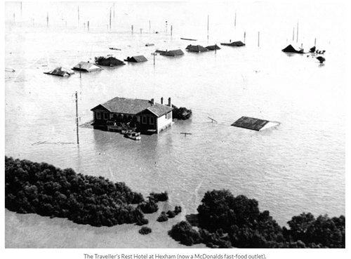
Flooding on the Hunter River first has impacts associated with the New England Highway and Maitland Road, in which the Eastbound lanes are first impacted by floodwater. In larger events, overbank inundation of 0.5m to 1.0m can occur at Hexham causing low-lying inundation and road closures. In events of 1% AEP or those similar to that of 1955 Hexham can see widespread, deep inundation of several meters. Notably, in 1955 the now ‘McDonalds’ was approximately 3 meters underwater.
Flooding occurs often in Hexham and Sandgate, often nuisance in nature and occurring with high-tides, impacts are minimal. In more serious events, the highway has been closed for periods of time, dependent on the height of the Hunter River.
As mentioned, the 1955 flood demonstrated the risk that exists within the sector, it is estimated that 1955 was less than a 1% chance of occurring in any one year.
To understand what happens in a Hexham flood, it is important that all residents and businesses know:
The Bureau of Meteorology (BoM) reads and refers to the Hexham Bridge gauge (210448).
HEXHAM BRIDGE GAUGE
|
Height (m) |
Relevance / Action |
|
4.10m |
Peak Height February 1955 |
|
3.80m |
Major Flood Level |
|
2.90m |
Moderate Flood Level |
|
2.30m |
Estimated 5% AEP Event |
|
1.90m |
Minor Flood Level |