Potential Damaging Winds & Snow Impacting Southern NSW
04/07/2018 05:04 PM
NSW SES are planning for preparations for potential severe weather impacting Southern NSW from Friday.
The Bureau of Meteorology have provided a heads up for potential damaging winds and snow impacting the Central, Southern Ranges and Illawarra and South coast locations from early Friday 6 July to Sunday 8 July.
Cold fronts will move across southern NSW on Friday and Saturday, bringing cold and windy conditions, particularly across the south, so rug up!
Friday will be windy across the southeast from the early morning. The locations most at risk are the Alps, Illawarra, and South Coast, and eastern parts of the Southern and Central Ranges. Snow will fall about the Alps from later on Friday.
With more families travelling on the roads these school holidaying, NSW SES advises holidaymakers to plan their trip before heading off, visit the Live Traffic website for changes in traffic conditions and road closures.
Before leaving home, make sure loose items such as trampolines, outdoor furniture and play equipment are tied down or secured. Household objects can blow around in strong winds and end up in the neighbours’ yard and on the streets.
Make sure your roof is in good repair and fix any broken or damaged tiles.
For more information regarding he weather situation, visit the Bureau of Meteorology website for more details.
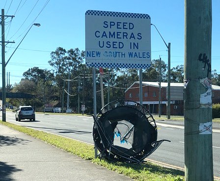
Picture taken last month of an old trampoline that had been blown away by strong wind and caught by a police street sign.
Related Pages: Prepare You Home And Business